
Release Date :
Reference Number :
2024-SR-040
SPECIAL RELEASE
Land Ownership in Oriental Mindoro (Results of 2020 Census of Population and Housing)
About three in every ten households in Oriental Mindoro own other land
In the 2020 Census of Population and Housing (2020 CPH), 61,415 households or 28.6 percent of the total 215,071 households in Oriental Mindoro reported that they own at least one land apart from the land that they own/occupy at the time of the census.

Among the 14 municipalities, Bulalacao (San Pedro) had the highest proportion of households with at least one type of land they owned other than the land they occupy, with 51.8 percent or 5,107 households. It was followed by Mansalay with 42.4 percent or 5,658 households, and Baco with 37.5 percent or 3,443 households. Moreover, the City of Calapan reported 21.6 percent or 7,587 households with at least one type of land they owned other than the land they occupy.
Meanwhile, the municipalities of Pinamalayan and Puerto Galera had the lowest proportion of households with at least one type of land they owned other than the land they occupy, both at 20.5 percent or 4,372 and 2,042 households, respectively.
One in every five households in Oriental Mindoro owns agricultural land/s
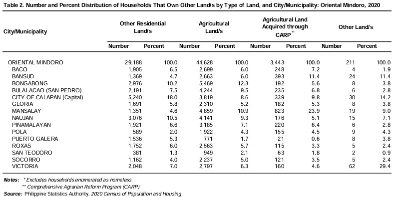
Of the total 61.42 thousand households, 44.63 thousand (20.8%) were reported to own agricultural land/s. Households that owned other residential land/s totaled to 29.19 thousand (13.6%) while households that owned agricultural land/s acquired through the Comprehensive Agrarian Reform Program (CARP), as agrarian reform beneficiary reached 3,443 (1.6%). Only 211 households (0.1%) had members that owned other types of land/s.
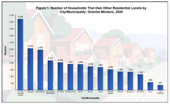
City of Calapan posts the biggest number of households that own residential land/s
The City of Calapan posted the highest number of households that own residential lands, with 5,240 or 18.0 percent of the total 29,188 households that own residential land/s in Oriental Mindoro.
Among the 14 municipalities, Naujan posted the highest number of households that own residential lands, with 3,076 households or 10.5 percent of the total households that own residential land/s in the province. It was followed by Bongabong with 2,976 households (10.2%) and Bulalacao (San Pedro) with 2,191 households (7.5%).
The municipality of San Teodoro, on the other hand, reported the least number of households that own residential lands with 381 households (1.3%) of the total households that own residential land/s in the province.
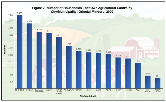
Number of households that own agricultural lands is highest in Bongabong
The municipality of Bongabong had the highest number of households that own agricultural lands with 5,469 households or 12.3 percent of the total number of households that own agricultural land in Oriental Mindoro. It was followed by Mansalay with 4,859 households (10.9%) and Bulalacao (San Pedro) with 4,244 households (9.5%).
Ownership of agricultural lands was least in the municipality of Puerto Galera with 771 households (1.9%).
The City of Calapan recorded 3,819 households that own agricultural lands which corresponds to 8.6 percent of the total number of households that own agricultural land in the province.
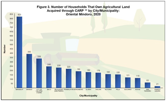
Ownership of agricultural land/s acquired through CARP is most common in Mansalay
The highest number of households that own agricultural lands acquired through the Comprehensive Agrarian Reform Program (CARP) in Oriental Mindoro was registered in the municipality of Mansalay with 823 households or 23.9 percent. It was followed by the municipality of Bansud with 393 households (11.4%) and the City of Calapan with 339 households (9.8%).
Puerto Galera posted the least number of households that owned agricultural land/s acquired through CARP with 21 households (0.6%).
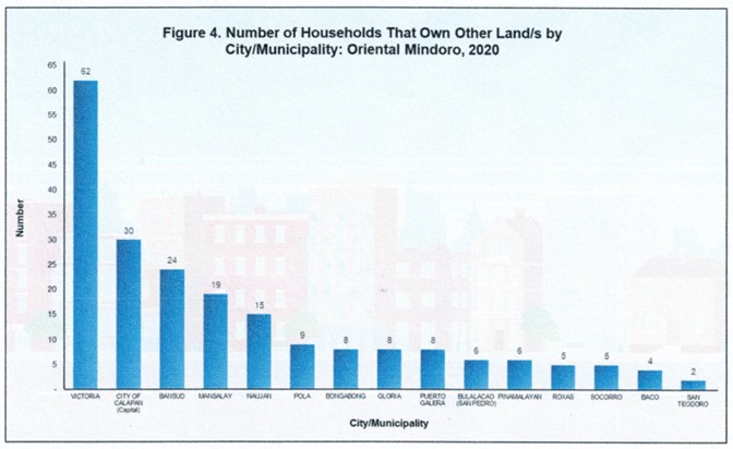
Victoria registers the biggest number of households that own other types of land
The number of households that own other types of land recorded the highest in Victoria with 62 households or 29.4 percent of the total number of households that own other types of land in the province. Other lands include lands that are used for commercial, industrial, or recreational purposes. It was followed by the City of Calapan with 30 households (14.2%), and Bansud with 24 households (11.4%).
San Teodoro posted the smallest number of households that owned other types of land with only 2 households (0.9%).
The statistics presented in this report were based on the information provided by the respondent or any responsible household member who may provide accurate answers to the questions and give correct information about the household. Moreover, the number of households in this reports excludes households enumerated as homeless.
In the 2020 CPH, data on the land ownership were collected by asking the respondents, "Does any member of this household own the following?
1. Other residential land/s;
2. Agricultural land/s;
3. Agricultural land/s acquired through Comprehensive Agrarian Reform Program, as an agrarian reform beneficiary;
4. Other land/s."
(SGD) DONNA MARIE D. MOBE
(Supervising Statistical Specialist)
Officer-in-Charge
Oriental Mindoro Provincial Statistical Office
TECHNICAL NOTES
The population and housing censuses in the Philippines are conducted on a “de jure” basis, wherein a person is counted in the usual place of residence or the place where the person usually resides. The enumeration of the population and collection of pertinent data in the 2020 CPH referred to all living persons as of 01 May 2020.
For land ownership in the 2020 CPH, the respondent was asked, “Does any member of this household own the following...?” This determines if the household has any member/s who own other lands aside from the one that the household is currently occupying. The data were collected using the CPH Form 2 (Common Household Questionnaire).
DEFINITION OF TERMS
Household is a social unit consisting of a person or a group of persons who sleep in the same housing unit and have a common arrangement in the preparation and consumption of food.
Agricultural Land/s refers to land/s devoted to or suitable for the cultivation of the soil, planting of crops, growing of trees, raising of livestock, poultry, fish, or aquaculture production, including the harvesting of such farm products, and other farm activities and practices performed in conjunction with such farming operations by persons whether natural or juridical and not classified by law as mineral land, forest land, residential land, commercial land, and industrial land.
Residential Land/s refers to All lands that have been identified and zoned as residential through the appropriate ordinance by the Local Government Unit (LGU) having jurisdiction over the area. These include residential lands within areas zoned as mixed residential and commercial or mixed residential and industrial (Source: RA 10023, Series of 2010).
Other Residential Land refers to residential lands that the household owns other than the one they are occupying.
Other Land/s include commercial lands, industrial lands, ancestral domains, and ancestral lands. The last two categories are distinguished from Torrens Title and other tenurial instruments granted by a government agency or by the court.
Agricultural land/s, acquired through Comprehensive Agrarian Reform Program, Agrarian Reform Beneficiary pertains to land ownership acquired through Emancipation Patent (EP) Holder, Certificate of Land Ownership Award (CLOA), and Homestead Patent (HP), Leasehold Contract (LC).